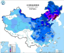
Recently, most parts of China have experienced high temperatures, with many underfloor heating systems breaking records. Starting tomorrow (November 15th), strong cold air will affect many parts of China, and many places will experience a major reversal of temperature, with a temperature drop of over 15 ℃。

On the 15th, the main impact was in the northwest region; On the night of the 16th, the front of the cold air roughly advanced to the middle and lower reaches of the Yangtze River; On the night of the 17th, its vanguard can advance to the southern region of China; From the 18th to the 19th, temperatures in many parts of the central and eastern regions will turn lower, dropping to the recent trough
Cold and warm are about to undergo a major reversal The highest temperature in Guangzhou next week may drop to just over 20 ℃
The ones who are most looking forward to this strong cold air coming to cool down are definitely the friends in southern China. After all, others are looking forward to the first snow in the beginning of winter, while the southern region of China is still blowing air conditioning and wearing short sleeves during the beginning of winter。

Before the arrival of cold air, the warm and hot weather in southern China will continue for about 4 more days, and the highest temperatures in some places may even break historical records. However, the abnormally high temperatures have also left ample room for cooling, with some areas in southwestern and southern China expected to experience a temperature drop of nearly 10 ℃. The highest temperature in Guangzhou on the 16th was still 30 ℃, and it may drop to just over 20 ℃ by the 20th, with the heat dissipating。
Special reminder: During this cooling process, there has been a drastic change in temperature in many places, with significant differences in body sensation. The lowest temperatures in various regions are mostly around the 18th to 19th. The public should pay attention to adding clothes and keeping warm in a timely manner to prevent catching a cold。
Taozhi brings Guangdong Strong winds and rainy days
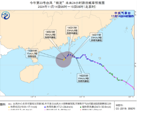
In addition to the precipitation brought by cold air, typhoons will continue to bring wind and rain impacts to our country in the coming days. The center of Typhoon "Taozhi" (tropical storm level), the 23rd typhoon of this year, was located on the northern sea surface of the South China Sea, about 480 kilometers northeast of Yongxing Island in Xisha, Sansha City, Hainan Province, at 5 o'clock this morning (14th). The maximum wind force near the center was 9 levels (23 meters/second). 。
Affected by the peripheral circulation of "Taozhi", there will be light to moderate rain in Guangzhou until the 15th, with gusts of 4-6 levels on land and 6-8 levels in the port area and highlands. 。
Specific forecast for GuangdongOn the 15th, some cities and counties along the coast of eastern Guangdong and in the east of the the Pearl River Delta were overcast, with light to moderate rain and local heavy rain. Some cities and counties in northern Guangdong were cloudy to overcast, with scattered light rain, and other cities and counties were mainly cloOn the 16th, most of the province was cloudy with light rain in some areas. On the 17th, the cities and counties in eastern Guangdong and the southeast of the the Pearl River Delta were cloudy to overcast, with light rain in some areas and mainly cloudy in other cities and counties
Read the original text:https://mp.weixin.qq.com/s/ESVQD0vOfOVkuUYB_0a17g
|